Precisely MapInfo Professional
Location-based decisions: Explore, model and act with confidence

Access more data, gain richer insight and find the right answer with ease using MapInfo Pro v2023
- Brand new 3D visualisation
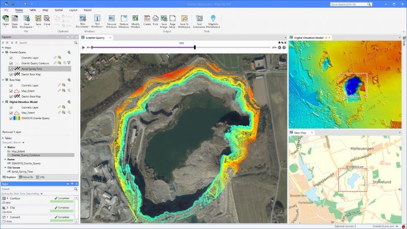
- Temporal (Time) Mapping feature
- Integration with Spectrum Spatial
- Enhanced Virtual Raster capabilities
- Tile Server Reprojection
- MapInfo Marketplace access
- Drone data add-in
- Heat maps
- Free MapInfo Pro Viewer installation provides easy access to non-specialists
- Completely re-designed SQL tool
- Geocode tool accessible directly within MapInfo
- Use smart text for dynamic information in the layout
- Ribbon and mini-toolbar customization
Download
a free v2023 30-day evaluation, including MapInfo Pro Advanced
See what's new in MapInfo v2023
MapInfo Pro is a leading geospatial solution used by commercial, government, public sector and charities globally.
MapInfo Pro is also one of the most widely used GIS packages in the minerals and environmental industries.
Now available as MapInfo Pro Advanced on annual subscription,
with the Advanced Raster, Bing imagery and 3D tools included in all subscriptions.
with the Advanced Raster, Bing imagery and 3D tools included in all subscriptions.
Latest release: v2023.1
The latest release of the world's most intuitive mapping and GIS application just got even simpler, faster and smarter, enhanced by user feedback.
v2023.1 extends the MapInfo Marketplace, a central repository for MapInfo-based apps, datasets, custom symbols and layout templates available from within MapInfo.
Includes DrawTools with support for 3 D M/Z values, and What3Words 3D Visualisation
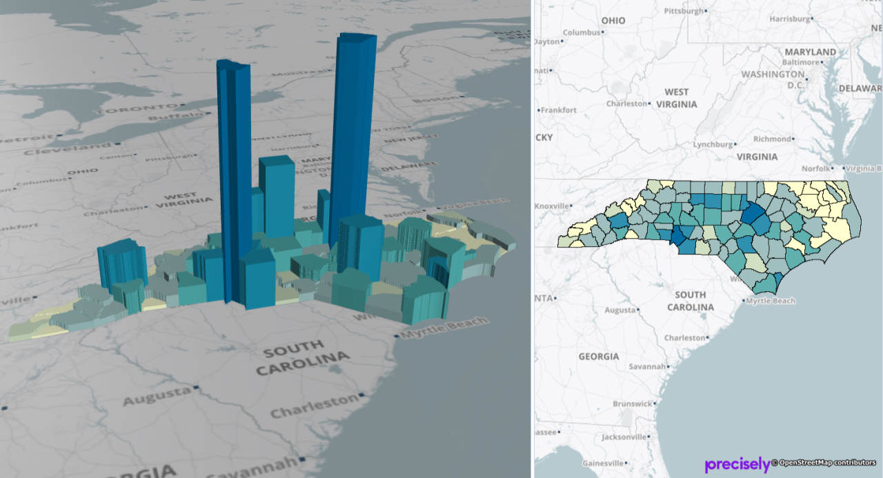
- Gain deeper insights by visualizing your 3D data using OpenGL rendering
- Display data in 2D and 3D simultaneously to reveal patterns and relationships not seen in traditional representations
- Add dimension to your data by appending elevation (Z-value) or other dimensional attribute (M-value) with MapBasic statements
Easy to use
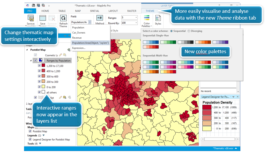
Create thematic maps with ease. Update your legend and data range bins without leaving your map.
- Interactive and intuitive
- Ribbon-based navigation
- Quick-click dropdowns and rollover displays
- Instant feedback from gallery controls
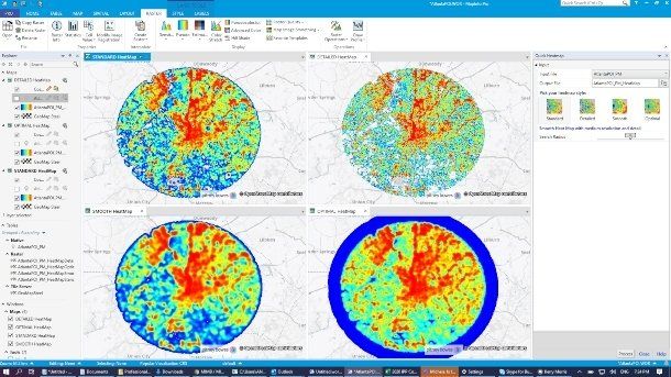
Instant Heat Mapping
Turn your data into insights using the new heat mapping available within MapInfo Pro.
Start with any file of people, places, or things and visualize the density of the locations as “hot spots” that help you make better decisions. For more power, upgrade to MapInfo® Pro Advanced and work with all kinds of raster data using the fast, highly compressed MRR format.
Faster
Visualize data in less time than ever and update themes, layers and legends instantly.
Take advantage of our next generation raster GIS capabilities with MapInfo Pro Advanced, giving grid analysis capabilities with very large raster files.

Simpler querying / filtering
Find, segment and update your data faster and easier with the new SQ L Window and "select by attribute" capability.
Users can build and save SQL statements and MapBasic scripts. This helps to increase productivity by building,
running and reusing scripts.

Free MapInfo Pro Viewer
- Open and view MapInfo Tables and Workspaces without a full MapInfo Pro licence.
- Easily share your workspaces with colleagues and clients.
Data Compatibility
Now you can access even more data where it lives or whatever its format.
MapInfo Professional makes the most of your IT investments with support for open source PostGIS, Microsoft SQL Server and SQLite, MS Excel and Access, Bing Imagery, as well as support for OGC WFS, WMTS and Geopackage data, and in 2021 new support for a whole host of vector formats (KML/KMZ/GeoJSON...).
Easy Results Sharing
- Print, publish and share your maps with ease.
- Add legends and charts using our Wizards.
- Share, save or export data in commonly used formats.
- Take fast action from your insights.
Data creation and editing
Access a vast selection of data creation and editing tools.
- Edit your tabular and spatial data.
- Utilize over 40 CAD-like utilities.
- Make changes to all your maps and data in a single application.
The Location Intelligence Suite
Access a comprehensive set of integrated GIS offerings.
- Server, web and mobile mapping and GIS applications.
- A comprehensive data catalogue of over 350 datasets.
- Accurate global geocoding
- Data quality and integration capabilities
- Business Intelligence platform support.
MapInfo Pro Optional Extensions
MapInfo Pro Premium Services:
Up-to-date worldwide street mapping at the click of a button.
Access to Bing Road Maps.
MapInfo Pro Advanced Raster:
High-resolution grid data of immense size handled with ease.
Powerful grid analysis (line-of-sight, slope calculations, hill shading).
Used with Discover
or Discover 3D, MapInfo Pro provides an even more powerful GIS tool for visualisation and analysis of 2D or 3D data.
MapInfo v12.5
In v12.5 we saw improvements in the design of MapInfo:
Sort or filter data directly in the browser window, reducing the need for complex SQL queries
Labelling has improved beyond recognition
Better control over the Legend Window
In-window editing using the layout window
Easily publish maps to the cloud to share analysis with colleagues or customers using MapInfo Stratus, an integral part of the MapInfo Suite.
MapInfo Pro v15 32-bit
MapInfo Pro v15, released in June 2015, is a 32bit product. There will be no further updates or upgrades of the 32-bit release from October 2016.
MapInfo Pro 64bit was first released with v15.2 in Q3 2015. v16 is the latest release, from November 2016.
Contact us
now for information about the latest release.
MapInfo Pro v16 64-bit
MapInfo Pro v16, released in November 2016, is a 64-bit product. View the MapInfo Pro 16 Datasheet.
v16 gave us more flexible map displays, instant customization of menus, advanced analytics, smarter calculations, and more speed than we have ever seen before in MapInfo.
MapInfo Pro 64bit was first released with v15.2 in Q3 2015.
MapInfo Pro v17 is the latest release, from April 2018.
View the v17 release notes, orcontact us
now for information about the latest release.
MapInfo Pro v17 64-bit
MapInfo Pro v17, released in 2018, is a 64-bit product. View the MapInfo Pro 17 Datasheet.
v17 gave us more further thematic improvements, MapInfo Marketplace, even better geocoding, automatic backup of customised user settings, customisable single-key shortcuts, and almost complete reconstruction of "lost" 32-bit functionality.
MapInfo Pro 64bit was first released with v15.2 in Q3 2015.
MapInfo Pro v2019 is the latest release, on 28 November 2019.
View the v2019 release notes, or contact us
now for information about the latest release.
Supported Operating Systems (64-bit)
Windows® 7 64-bit SP1
Windows® 8.1 64-bit
Windows® 10 64-bit
Windows 2012 Server R2 (64-bit only)
Windows 2012 Server R2 (64-bit with XenApp 7.5)
Windows 2019 Server (64-bit)
Windows 2019 Server (64-bit with XenApp)
Supported Databases:
XY - i.e. Databases that store point data as X & Y numeric columns:
Microsoft Access 2007, 2010
Microsoft Office 2013, 2016
Spatial - Databases that store map data as objects including: points lines and regions
Microsoft SQL Server (also called SQL Server Spatial)
Oracle Spatial 11Gr2, 12cR1
PostgreSQL 9.0.3 with PostGIS 1.5
PostgreSQL 9x with PostGIS 2.1x
SQLite
Database Connectivity:
Microsoft SQL Server 2012
Microsoft Access ODBC and other ODBC-compliat databases
OGC GeoPackage
PostGIS

